
With hills and mountains enveloping it on all sides, the Vang Vieng comes with hiking trails for any enthusiast of all ages and fitness levels. Whether you’re a beginner or a seasoned pro, hiking here can make for an ideal day out, whether alone, with friends, or as part of a guided group excursion.
As self-proclaimed hiking enthusiasts, we’ve explored numerous viewpoints and peaks in the area. With self-identified hiking enthusiasts, we have hiked to several viewpoints and peaks. This blog covers all the hikes in Vang Vieng, including the difficulty level, entry fee, altitude, and anything else you might need to know before lacing up your hiking and hitting the trails.
Best Hiking Trails in Vang Vieng, Laos

Table of Contents
1. Pha Poak Mountain
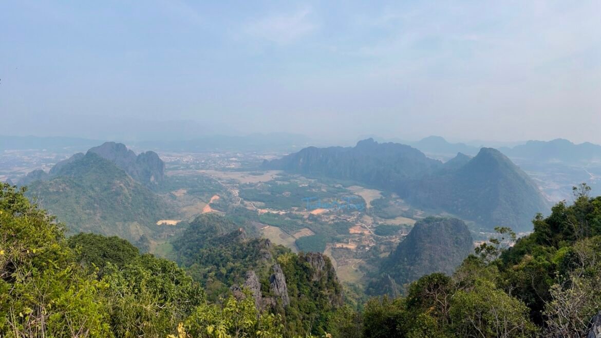
Also known as Pha Daeng, Pha Poak Mountain offers more of a climb than a hike. While the viewpoint is within walking distance from the city, it’s Pha Poak Mountain for those seeking adventure. A wooden gate marks the start, leading you through rice fields to the mountain’s base. Wooden ladders are provided for steep sections, and a small cave can be found along the way if you take a brief detour. The trail is marked on OSMAND and maps.me, with a Lao flag at the summit. Once there, the breathtaking 360° view of the surrounding mountains, rice fields, Nam Song River, and Vang Vieng City will leave you in awe.
- Difficulty Level: Moderate due to the steepness
- Highest Altitude: 260 m
- Distance: 500 m
- Duration: 40 minutes to 1 hour for the ascend, 30 minutes to descend.
- Entry Fee: Free
2. Pha Ngern Viewpoint
Pha Ngern offers a less crowded option than other viewpoints in Vang Vieng. The hike begins near the restroom at this location. You’ll start by climbing stairs through the jungle, then navigate rocky terrain with a steep ascent. At the top, you’ll find three viewpoints offering panoramic 360° views of the surroundings. The walkway to the viewpoint is constructed of durable bamboo and wood. Trails are clearly marked on OSMAND and maps.me.
- Difficulty Level: Easy – Moderate
- Highest Altitude: 560 m
- Distance: 1.25 Km one way
- Duration: 1 hour to ascend, 1 hour to descend.
- Entry Fee: Free
3. Pha Ngern Silver Cliff Viewpoint
Commonly known as the Silver Cliff Viewpoint, Pha Ngern Silver Cliff Viewpoint is a popular spot that is ideal for beginners. The hike involves some climbing and can be challenging and steep, especially near the summit with many rocks. While it’s a well-liked viewpoint, you’ll encounter fewer people here than Nam Xay Viewpoint. The trail is clearly marked on both OSMAND and maps.me. At the summit, you’ll find a shelter with a Lao flag. Two motorbikes parked at the top make for a picturesque scene.
- Difficulty Level: Easy – Moderate
- Highest Altitude: 360 m. The viewpoint is at 330 m.
- Distance: 0.6 Km or 600 m one way
- Duration: 30-40 mins for the ascend, 20 mins for descend
- Entry Fee: 20000 KIP (1 USD)
4. Silver Cliff Viewpoint One & Big Pha Ngern Viewpoint Top

Unlike the Silver Cliff Viewpoint, the hike starts at the Pha Nguen Trailhead, marked on Google Maps. This challenging trek leads you to two viewpoints: the Silver Cliff Lower Viewpoint and the Big Pha Ngern Viewpoint Top. It’s the toughest hike on the list. We’ve completed this hike and written a detailed blog with plenty of information and tips. Check it out for more details.
5. Phapoungkham Cave and Viewpoint
Also known as Pha Hon Kham Cliff, it’s situated near the Nam Xay Viewpoint. This hike attracts fewer tourists. The trail involves a steep climb up stones and ladders, leading you to the top. The trail splits into two paths – one leading to an airplane viewpoint and the other to the pegasus or flying horse viewpoint. You can also find a small cave and a Buddha statue along the way. Also, note that Phapoungkham Cave differs from Phu Kham Cave, which is close to Blue Lagoon 1.
- Difficulty Level: Easy – Moderate
- Highest Altitude: 340 m
- Distance: 567 m to see both viewpoints, one-way
- Duration: 30 minutes for the ascend, 15 mins to descend
- Entry Fee: 20000 KIP (1 USD)
6. Nam Xay Viewpoint

The Nam Xay Viewpoint is the most popular in Vang Vieng. It’s a must-visit for many travelers, especially around sunset, when it’s bustling with tourists enjoying the breathtaking views. The hike is relatively easy but steep. We’ve hiked to this viewpoint ourselves and have written a detailed hiking guide. Check it out for more information.
Important Things to Note
- Considering that Laos is the most heavily cluster-bombed country in the world, our advice is that you do not deviate and venture into far-off spots from your existing trail. Sticking to the trail throughout the hike is safe and recommended.
- Download the offline maps in that area in both maps.me and OSMAND. The trail is marked in both applications. You can crosscheck to make sure you’re following the correct trail.
- Using plastics and smoking is strictly prohibited. As a hiker, you must keep clean and not litter. Pick up your trash with you and dispose of it in the proper dedicated bins.
- There is no source of water available on this hike. Make sure to carry enough water with you.
- Shops can be found at the viewpoints of a few hikes or the base. It is better to carry your snacks and energy bars from the start.
- We highly recommend you wear good hiking shoes as the terrain is slippery, even during the dry season.
- Disclaimer: You can find leeches during monsoon season. Learn how to treat leeches the right way.
Essential Things To Carry
- Ensure you carry at least 1 L of water per person.
- Take sufficient energy bars and snacks.
- Have your first aid kit handy.
- Do not forget your head torch if you plan to camp overnight or hike during the golden hours.
- Cap, sunscreen & sunglasses are essential and absolutely non-negotiable to ward off the summer heat.
- Carry a poncho or raincoat in case of rain.
- Above all, ensure you wear comfortable shoes with good traction and grip.
Read the blog to know more about what we usually carry for day hikes.
Frequently Asked Questions
Can I do two or more hikes in a day?
Yes, you can combine two easy-to-moderate-level hikes and complete them in a single day. Note that this is highly subjective to your fitness level.
If I have only one day, which hike do I need to take in Vang Vieng?
If you’re tight on time but still want to hike in Vang Vieng, consider Nam Xay Viewpoint, Silver Cliff Viewpoint, and Phapoungkham Cave and Viewpoint. These hikes are easy to moderate and can be combined with other activities in Vang Vieng.
Are guides mandatory for hiking in Vang Vieng?
No, guides aren’t required to hike in Vang Vieng. You can do the hike on your own. All the trails are well-traveled and clearly marked, making navigating easy. Many of them are also mapped on offline navigation apps like OSMAND and Maps.me.
Which hikes in Vang Vieng are perfect for sunset and sunrise?
All the hikes mentioned above, except for the Big Pha Ngern Viewpoint Top, can be done at sunrise and sunset. Sunrise offers fewer crowds and the chance to see hot air balloons in the sky, making it ideal for hiking. However, Nam Xay Viewpoint and Silver Cliff Viewpoint tend to be crowded at sunset.
Is camping allowed at the viewpoints in Vang Vieng?
Yes, camping is allowed at the viewpoints. No extra charges are collected for camping. Camping is not popular in Vang Vieng but is most popular in Nong Khiaw.
If you’ve found this blog helpful, drop a comment down below! And if you’re eager for more extensive hiking guides and travel tips, don’t forget to subscribe to our newsletter and give us a follow on social media – find us on Instagram, Pinterest, and YouTube!