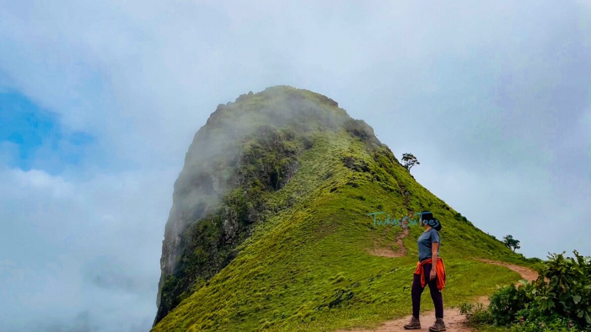

Famously known as Shishila Gudda among the locals, Ettina Bhuja has been gaining steady popularity over the years as the ideal beginners’ trek. It offers interesting unique scenic views, like the standalone peak in the region. This peak alone makes the entire climb a very rewarding experience. Every ardent trekker must undergo this climb to be able to truly admire and appreciate the various awe-inspiring perspectives of nature.
On a week-long trip in the Chikmagalur district during the monsoon month of July, we explored and hiked various peaks, and yet few came close to the allure of Ettina Bhuja. This essential guide will give you all the information and tips you need to ensure that you plan and complete this trek by yourself.
Ettina Bhuja Hiking Guide
Table of Contents
Why The Name Ettina Bhuja?
Ettina Bhuja got its name from the peak that resembles an Ox’s shoulder or Ox’s hump. Bhuja in Kannada translates to “shoulder”, and Ettina translates to “of the Ox”.
Ettina Bhuja Forest Official Contact
Harish – +91 9901369184 (speaks Hindi, English, Kannada, and Tamil)

Two government forest officials can be seen at the checkpost. It is open at 9 AM during weekdays and as early as 6 AM during weekends and holidays. Their shift ends at 5 PM after which you are denied entry.
How To Reach Ettina Bhuja From Mudigere?
By Train
There is no railway network to reach Ettina Bhuja. The only option is to arrive by road.
By Road
If you are dependent on public transport, board a bus to Byrapura from Mudigere and get down at the last stop. From there walk for 500m to reach the Nanya Bhairaveshwara Temple; the base of the hike.
The first bus departs from Mudigere at around 5 AM and reaches at 6 AM at Byrapura. The last bus from Byrapura departs by 5:30 PM. Plank your hike accordingly to ensure you are present when the last bus departs from Byrapura.
We recommend reaching the base through means of personal transport, that way you are in no time constraint or rush. You also have the flexibility of stopping at your own pace and sightseeing at your convenience.
Note: No two-wheeler rentals are available in the villages of Byrapura and Mudigere. People usually rent their vehicles from Chikmagalur and complete the trip during the day.
Network Availability
Shortly after you start from Mudigere, you will be out of network till you reach the Nanya Bhairaveshwara temple which is the starting point of the trek.
Airtel and Jio provide poor to moderate reception of internet and the cellular network can be accessed at the summit. BSNL provides nil coverage at these places.
ATM Availability
There are no ATMs available nearby. The closest ATMs can be found only in Mudigere town located approximately 15 Km away from Byrapura, so ensure you carry sufficient cash.
Please note that UPI payments cannot be made due to poor to nil network coverage.
Languages Spoken
Kannada, the regional language, is the only language spoken by the residents.
Parking Availability

Sufficient parking space is available at the base of the trek, near the temple. The parking charges are Rs. 25 for a two-wheeler, Rs. 50 for a car and Rs. 100 for a van or bus.
There is no petrol bunk available en route once you leave Mudigere. So, fill your tank in Mudigere itself.
Restroom Facilities
Clean and well-maintained restrooms are available near the parking lot. These can be used free of cost.
Best Time To Visit
The best time to visit Ettina Bhuja is during the post-monsoon months between September and December. At this ideal time, you get to see spectacular mountains in all their glory, littered with different shades of green and without the interference of mist.
We recommend going during weekdays. You can have a place for yourselves. Weekends and holidays tend to be crowded.
Where To Eat?

There are no restaurants available in the village of Byrapura. There is only a small shop (shown in the picture) where you can buy snacks or take quick bites like Maggi or Bread Omelet.
Please bring reusable water bottles with at least 1 liter of water per person. There is no natural water source to refill your bottles en route during the hike.
Where To Stay?
There is no homestay available as of 2022 on the nearby premises. One homestay is in construction and is said to start operating in 2023. The homestay can be found after the forest check post office.
Usually, people start early from Chikmagalur or stay at Mudigere, the most ideal alternative. There are numerous hotels and lodges available in both places.
Things To Do In Ettina Bhuja
Hiking is the most popular activity in Ettina Bhuja. The pilgrimage visit to the Nanya Bhairaveshwara temple is also common among locals.
Hiking Details
Distance from Chikmagalur: 55 Km, 25 Km from Mudigere.
Cost: Rs. 50 per person to be paid at the check post for entry. Earlier officials used to charge Rs. 250, and you were given a guide. But now, there are no guides.
Registration: No registration or online booking is required.
Permission: You need to get permission from the forest department officials to pass the checkpost to continue the trek.
Timings: From 6 AM to 5 PM.
Duration: 1-2 hours for the ascend, 30-60 minutes to descend.
Summit Height: 1300 m
Hike Distance: 2 Km, one way

There is only one steep uphill climb at the bottleneck of the summit. However, there are large boulders that you can leverage and balance yourself upon to cross with little to no effort.
Terrain: Stones, rocks, and boulders. The muddy trails are slippery during the monsoon seasons
Difficulty Level:
While the trek is easy, it being a physical activity makes it highly contingent on your fitness level.

Hiking Route:
The hike starts from the Nanya Bhairaveshwara temple. There is no place to freshen up here, except the restrooms. The left visible route is your go-to way. After crossing the muddy terrain for about 100 m, you will find the forest check-post office. After a few meters, take the right turn when the path forks.

According to the Hindu myth Ramayanam, Ram, and Sita are said to have crossed this route during their exile in the forest. You can find the black Kumkum in one of the trees towards your right in a tree hole en route. Hindus usually place them on their foreheads as ‘thilak.’

After a few meters, the trail narrows and you can notice that the directions are marked with name boards impaled on the trees. We saw three boards guiding us to the summit. The sound of insects and gushing waterfalls can be heard constantly soaring into your ears as you progress.

After crossing the small hilltop, you will reach the open terrain. Here, the peak can be clearly seen. After that, it is a straight visible route to the summit. Clouds play hide and seek on the summit with slight drizzles and cool breezes during the monsoon making the weather near perfect for your hike. The forest check-post office, the temple, and the newly constructed homestay can be seen when you reach the open terrain, just before the final push to the summit.
The summit push is slippery during monsoon with stones easily giving way when set afoot. Ensure that you are very careful and aware of your surroundings and the terrain during the descent.
At The Ettina Bhuja Summit:

360° views of the continuous lush green mountains of Charmadi and Shishila Valley can be seen from the peak. The sound of nearby waterfalls along with the whistling wind creates a very pleasant ambiance. You can see Dhakshina Kannada and peaks like Deepadha Kallu, Ombathu Gudda, and JenuKallu Gudda to name a few.
Important Things To Remember
- The use of plastics and smoking is strictly prohibited. As a hiker, it is incumbent on you to be responsible and not litter. Collect and bring back the waste with you and dispose of it in proper dedicated bins.
- Illegal trekking is strictly prohibited, and trespassers will be prosecuted.
- Follow the clearly visible name direction boards with arrow marks placed on the tree branches to reach the summit. Stones and tree branches are placed at the other routes that are found along the hike to prevent you from being misled.
Essential Things To Carry
- Ensure you carry at least 1L of water per person.
- Take sufficient snacks and energy bars, as there is only one shop that is available 500m away from the base.
- Cap, sunscreen & sunglasses are essential to ward off the summer heat.
- Carry a poncho or raincoat in case of rain.
- Above all, ensure you wear comfortable shoes with good traction and grip.
- Leeches are present in this trek and the monsoon makes it worse, so carry leech-repellent spray like Dettol.
Frequently Asked Questions
Is Ettina Bhuja a sunrise trek?
You can do Ettina Bhuja as a sunrise trek. But people usually start during the daytime after 8 AM.
Is a guide required for the Ettina Bhuja trek?
A guide is not mandatory to trek the Ettina Bhuja. The directions are marked along the route guiding you as and when required. You can do this trek on your own without a guide.
Is camping allowed in Ettina Bhuja?
Ettina Bhuja is a reserved forest maintained by the government of Karnataka. Camping is strictly not allowed on the hill.
What are the places to visit around Ettina Bhuja?
You can visit the Bettada Bhairaveshwara temple, which gained a lot of mainstream popularity after the Love Mocktail 2 movie climax scene was shot, and other nearby places like Devaramane, Deepada Kallu peak, and Kala Bhairaveshwara temple.
Is a GPS file required to hike Ettina Bhuja?
No, a GPS file is not required to hike Ettina Bhuja. The route is straight and well-guided with directions. There is little to no chance of getting lost on this route.
Comment below if this guide was helpful to you while planning for your trip to Ettina Bhujja. For more DIY trekking guides such as this, stick with us and follow us on social media channels – Instagram, Pinterest, and YouTube.